A SPECIAL TRIP.
Following
the annual training (Wednesday, Thursday, Friday – December 3-5)for all CES
employees and senior missionary couples assigned to CES held in Hamilton, New
Zealand Sister Peron and I set out on a special
trip. We had received prior approval
from our mission president and our file leaders since the trip was to
destinations outside of our mission boundaries but within the country of New
Zealand. With Hamilton being located outside
our mission boundaries and with Institute being out for the summer now was the
perfect time for this trip.
In our
family history there are some tracks into Polynesia that stirred our desire for
this trip. First: Sister Perron’s
great, great, grandfather Noah Rogers was called by the Prophet Joseph Smith
and was the first missionary into the Isles of the Pacific in 1843 serving in
Tahiti. Sister Perron and I travelled to
Tahiti several years ago where we followed in some of his footsteps guided by
his journal. Second: Elder Perron
served here in New Zealand fifty years ago.
While here we have followed in some of his footsteps. Third:
We have some grandchildren with the last name of Hinckley and one of their
ancestors - Ira Hinckley – was one of the early missionaries sent by the church
to New Zealand. Some of Elder Hinckley’s
missionary experiences and Maori Traditions blend together so powerfully we
felt we needed to walk in some of his footsteps.
The next
several paragraphs – that can be found by searching LDS.org – tells of MOARI
TRADITIONS AND THE MORMON CHURCH and cites Elder Ira Hinckley.
“Latter-day Saint missionary work did not begin in New Zealand until 1854, and even then progress was
slow. Because of difficult conditions for the Church in Utah, the mission in
New Zealand was an on-again, off-again operation until the late 1870s. By that
time several branches of the Church had been established among the European
part of the population. But little had been done by our missionaries to attract
the native people, the Maoris, to the Church.
Most Maoris had been converted to
Protestant and Roman Catholic Christianity by the 1850s; but because they
believed they had been cheated in land deals by the whites, whom they called pakehas,
the Maoris made war on the pakehas. These wars lasted from the late 1850s until
the 1870s. When the wars ended, the time seemed to be right to take the
restored gospel to this outstanding part of the Polynesian race.
When William Bromley was called as
New Zealand mission president in 1881, President Joseph F. Smith told him that
the time was right to take the gospel to the Maoris. The first successes among
them came in 1883, but once the Maoris and the Mormons got together, Maori
converts flocked into the Church.
Why did the LDS Church appeal to
the Maoris? On the surface the Maoris seem very little different from their
Polynesian brothers and sisters elsewhere in the Pacific. But even though
Polynesians of all island groups have taken well to the restored gospel, the
Maoris appear to have been prepared in special ways for the coming of the Mormon missionaries.
In pre-Christian times the Maoris had a well-developed form of religion. Tohungas, or
priests, supervised worship and all else that was involved in this primitive
religious system. Sometimes these men took roles similar to the shamans of
northeast Asia. They became mediums for the atua, gods, whom they served. In
these roles, according to Eric Schwimmer, the tohungas would give oracles, cure
diseases, and admonish their people. After the establishment of
Christianity, however, some old tohungas continued to carry on their former
practices but now claimed to receive their revelations from a different source.
In other instances family patriarchs, village elders, and chiefs acted as prophets and were
“regarded with feelings of reverence and were credited with possessing
supernatural powers.” No fewer than five such men made prophecies
concerning the coming to New Zealand of the true church. As a result of such
prophetic utterances, a number of Maoris ultimately joined the Church.
Each instance of prophecy is of
great interest to Latter-day Saints. Two of these can serve as examples. In
1830, the year the Church was organized, an aged patriarch named Arama Toiroa,
who lived in the area of Mahia,
(area in New Zealand) gathered his children, grandchildren, and relatives
together and gave them some advice. (At that time most of his descendants had
joined the Church of England.) His people, who considered him a seer, listened
carefully to what he said:
“‘My dear friends, you must leave
that church, for it is not the true church of the God of heaven. The church you
have joined is from the earth and not from heaven.’
“Upon hearing this his people
asked, ‘Where then can we find a church where we can worship the true God?’
“Arama Toiroa answered, ‘There
will come to you a true form of worship; it will be brought from the east, even
from beyond the heavens. It will be brought across the great ocean and you will
hear of it coming to Poneke (Wellington) and afterwards its representatives
will come to Te Mahia.
“‘They will then go northward to
Waiapu but will return to Te Mahia.
“‘When this “Karakia,” form of
worship, is introduced amongst you, you will know it, for one shall stand and
raise both hands to heaven.
“‘When you see this sign, enter
into that church. Many of you will join the church and afterwards one will go
from amongst you the same way that the ministers came even unto the land from
afar off.’”
Fifty-four years passed before
Arama’s words were fulfilled. In 1884 Elders Alma Greenwood and Ira Hinckley
brought the gospel to the Wellington area and then made their way to Hawkes Bay (a coastal region of New
Zealand). There they were joined by
President William E. Stewart, and together they traversed the path Arama had
predicted. It was at Korongata,
however, and not at Mahia, that
Arama’s descendants first accepted the gospel. Brother Whaanga described the
day when the gospel was first preached to Arama’s people:
“In journeying northward they
reached … Korongata, where
many of us were assembled on the Sabbath day.
“Amongst the people who were
there was a grandson of Arama Toiroa whose name was Te Teira Marutu.
“The meeting was conducted by
Elder Stewart and his friends. The services were opened with singing and
prayer, and a Gospel address was delivered, after which they sang again, and
Brother Stewart arose to dismiss with prayer. In doing so he raised both hands
and invoked God’s blessing upon the people.
“As soon as the grandson of Arama
Toiroa saw this he arose and declared that this was the church of which his
forefather prophesied which would surely be firmly established amongst the
Maori people.
“He and his wife applied for baptism, and they and their children were thus initiated into the Church by
Elder Stewart.”
Subsequently the missionaries
returned to Mahia and held
meetings with other descendants of Arama Toiroa. After seeing the sign, these
people said, “This is indeed the church for us, for did not our revered
forefather, Arama Toiroa, prophesy about it?”
Largely as a result of this
prophecy, every person in Korongata
joined the Church, and a large number of Maoris in Mahia entered the waters of baptism.
By the end of 1884 the missionaries
had firmly established the restored gospel among the Maori people. The next
several years were very satisfying to most of the elders and sister
missionaries (several couples were sent to New Zealand beginning in 1885). In
August 1885, there were 16 Maori and 4 pakeha branches of the Church, and this
number continued to grow steadily for the next 15 years. At the close of 1887,
there were 2,573 Latter-day Saints, and by the turn of the century there were
nearly four thousand members of the Church in New Zealand. Most of the Maori
tribes, including large numbers in the north, around Whangarei and the Bay of
Islands, had been introduced to the gospel. In 1901 there were 79 branches.
Clearly, since the early years in Hawaii, the Church had not enjoyed so much
success with a Polynesian people.
Sister
Perron and I left Hamilton headed for Mahia,
New Zealand and Karaongato, New
Zealand where Ira Hinckley and his companion baptized many of Arama Toiroa’s
descendants.
Leaving
Hamilton we drove East to Tauranga where we spent the night and from there we
followed the coast – Pacific Coast Highway – to Gisborne where we spent the
night and attended church. This was
planned as Mahia is just south of Gisborne and many of the old time Maori
families still live in the area. In
particular we were looking for Paul Whaanga who in his 90’s and is still the
Gisborne stake patriarch. From Gisborne
we travelled to Mahia where we
walked the beaches and the hills taking pictures. Leaving Mahia we continued down the Pacific
Coast to the Hastings area where Karangoto
– [now Bridge Pa] is located. We spent
the night in the area visiting an old cemetery – which is right behind the LDS
church – taking pictures. There we found
some saints also visiting the cemetery – some of them were from Mahia.

This special trip was also special in the
sense that we were now traversing country that Elder Perron had not seen before
– this area was not in his mission 50 years ago nor is it in our mission
now. This trip was a delight. After visiting Korongato we returned home the
long way – travelled across the country to Palmerston North, up to Wanaganui,
and New Plymouth, across the forgotten highway to Taumaruni then to Turangi,
Taupo and back home through Hamilton.
Our trip
will be shared through the following pictures and comments.
Aroha Nui,
Elder &
Sister Perron
MAHIA – comments are below each photo

As we approached Mahia this was our first glimpse of the area across the Bay. Obviously the sea was very important to early Maori settlements for food and transportation.


On a hill just above Mahia looking back across the Bay where the previous pictures were taken. This area is obviously sacred ground to our family for it was in this area in 1830 KORONGATO – comments are below each photo

Leaving Mahia we
drove down the coast to Hastings, New Zealand (about 120 miles) to find Korongato. The Korongato of the past is todays town of
Bridge Pa. From this vantage point
Bridge Pa is center-left in the above picture.
Bridge Pa is about 15 miles inland from the ocean which is off to the
left of this picture.

We found Bridge Pa, New Zealand.

Upon driving further into Bridge Pa imagine our
excitement when we found this sign.
Marae is a Maori word denoting a traditional Maori gathering place. Even more exciting if you will notice just
behind the sign at the top right – by the telephone pole – is a LDS church
building.

With the original intent of our trip concluded and forever
placed in our memory we will share the rest of our trip by posting a few
pictures with comments:
where Arama
Toiroa told his people: “The
church you have joined is from the earth and not from heaven...you must leave
that church, for it is not the true church of the God of heaven…There will come
to you a true form of worship; it will be brought from the east, even from
beyond the heavens. It will be brought across the great ocean and you will hear
of it coming to Poneke (Wellington) and afterwards its representatives will
come to Te Mahia” Ira Hinckley and his companions brought the gospel
to Mahia

Sister
Perron standing beside a Maori carving in the entrance of the Armitage Hotel in
Tauranga, NZ

So much
beach – So few people - So many shells!
This is paradise! Popamoa Beach, NZ

Elder Perron
strolling Papamoa Beach at dusk. The
beach is in the Taurange / Mount Maunganui area.

Driving the
Pacific Coast Highway from Tauranga to Gisborne seemed to be one ocean vista
after another.

Beautiful.

Can you ever
see too many ocean vistas?

Enjoy it you
will never see it again!

The historic
Raukokore Anglican Church built in
1894. The church is Raukokore’s most
notable feature. The church stands
isolated close to the shore of Papatea Bay (about 24 miles west of Hicks Bay.) It is one of the most photographed churches
in New Zealand. We did not know it was
there; Just came around the corner and there is was. It was a nice addition to another
seascape. We stopped and walked through
the building. There was a note that
stated there would be “no services for
the next three weeks as the minister was going to be absent.” A sign also asking visitors to “forgive the smell under the baptismal font,
a whanua of penguins have made it their home and the mother penguin is feeding
them fish.”

Tokomare Bay - Sister Perron and I pulled off of the Pacific Coast Highway to take a walk on the beach, stretch our legs and see what kind of sea shells we might see. After a few minutes we drove a small road back up the Bay towards what appeared to be a small village and ran into some history.

We found old
abandoned buildings that were evidence of a once thriving businesses. A sing indicated that we were in Waima.

The
buildings had no roofs, long gone from the wind and rain.

By the brick
work and size of the buildings here in the middle of nowhere there has once
been a great enterprise.

Just past
the buildings we found a wharf jutting out into the bay of considerable length
and size. There was a sign posted
stating: “WARNING – HAZARDOUS AREA – Wharf collapse could endanger users. Visitors use at their own risk.” Another
sign said: “The wharf is in poor
condition. Use at your own risk. No more than 15 people on the wharf at once.
Stay off in big surf.”
History
books tell us that in 1905 a small jetty was built to help the farmers put
their wool in small boats and take it out to larger ships. Then a wool store and dumping shed were built
at the jetty. In 1909 the area came
alive with the formation of Tokomura Freezing Co. Ltd. Twelve butchers were brought in and the
facility was butchering 2,000 lambs and 100 cattle per working day. There was
now a butchering and freezing facility. That same year the New Zealand Shipping
Co built a large cargo and wool store.
The large wharf was built, It was the start of a boom that lasted
another 40 years. In the early years 400 vessels were handled annually. The freezing works closed down in 1953. The New Zealand Shipping Co had depot here
and the harbour operated until 1963.
There were by then more economical ways to get the product to the market
place.
Seems this was all history by the time I arrived in New Zealand in 1963.
Seems this was all history by the time I arrived in New Zealand in 1963.


Sister
Perron taking a stroll on Wainui Beach, Gisborne, NZ.

The port
city of Gisborne, NZ looking down from Kaiti
Hill Lookout.

The best inscription on a statute I
have ever read! Here at the park on Kaiti Hill Lookout. We found several notable events
memorialized. Sister Perron is reading
one: “IN MEMORY OF THE LATE PRINCESS DIANA WHO PLANTED THIS POHUTUKAWA IN
1983.”
Then... the
best one I have ever read. The
inscription on the statute said:
“ABOUT THIS STATUE – This statue was
placed here at the time of the bicentenary of the landing of Lieutenant James
Cook and the men of Endeavour in Poverty Bay in 1769 –the first known landing
of Europeans in New Zealand.
It was cast in bronze from an
original marble statute which had been purchased in Italy in the late 19th
century by Moss Davis, the owner of the Captain Cook brewery in Auckland.
In the belief that it was a replica
of James Cook it was gifted to the city and a twin bronze was placed on the
brewery in Khyber Pass, Auckland, despite concerns by those who recognized that
the uniform was not that of the British navy and the facial features bore
little resemblance to Cook.
Since October 1969 the statue has
been a source of delight for photographers and a source of embarrassment for
historians. Who is he? We have no idea.”

Our next
stop was Hastings, NZ in our quest to find Korongata. Sister Perron on top of Te Mata Peak where one has a 360 degree view of the Hastings, NZ
area. Korongata is in the valley behind
her.

Rush Munro’s
Ice Cream – New Zealand Famous! Every
guide book tells you to go to Rush Munro’s for ice cream if you are in
Hastings, NZ. One book said: “Rush
Monro’s, enough said!” Sister Perron and
I said, “We have to try this ice cream!”
We drove by Rush Munro’s about 6:30 P.M. and the place was closed. No sign with business hours. Oh, by the way there is only one Rush Munro
ice cream parlour. Disappointed we said,
“We will get some tomorrow before we leave town”. We went by about 10:45 A.M. and the store is
closed. There were other people there
who looked puzzled, climbed into their car and drove off. Just as we are ready to leave Sister Perron
noticed someone inside – behind the locked gate. She asks, “What time do you open?” “11 0’clock.”
Obviously we waited the few extra minutes – you can see in the picture
Sister Perron is sampling all the flavours.
NOTHING MORE NEED BE SAID – glad we did not miss it.

Lawn Bowl
tournament in Woodville, NZ. Driving
through the small town Sister Perron said, “Hey they are having a Lawn Bowl
game in there!” The club house was right
along the highway. She had never seen
the game played before so we parked and went in. There was a light drizzle of rain. The Club President came over to visit with us
and insisted on giving us a tour of the club house!

Next stop
Palmerston North, NZ where we stopped to walk around and stretch our legs. Reminder Christmas is approaching with the
decorated Christmas Tree. (This picture
was taken 10 December 2014.) This park in
right downtown and we stopped at the i-site store for information on places to
visit in the area and to book a motel in Wanganui, NZ.

The International
Pacific College is located in Palmerston North, NZ. It so happens that the day we stop at the i-store
is the day and hour of their graduation ceremonies. There is about to be a processional for the
graduating students. These Japanese
students (Taiko Drummers) are waiting to put on a performance for the graduates
as part of their graduation ceremonies.
While they were waiting for the processional and we were waiting we
started visiting with them and ended up getting a picture with them.

We can hear
the bag-pipes playing and the processional is said to be twenty minutes away so
the drummers and dancers are getting into place. THIS WAS SUCH A HIGH ENERGY PERFORMANCE! We have a video of the performance everyone
needs to see. We ended up standing right
beside the president of the college before the event was over. We were not giving up our favoured spot! The processional and ceremonies concluded
right here following the Drummers performance!
The now empty plaza was packed with people and we were front and centre.

Our motel in
Whanganui, NZ. Whanganui is located on
the West Coast of New Zealand where the Whanganui River empties into the Tasman
Sea. The Whanganui River is the longest
navigable river in New Zealand and an integral part of the area, shaping the
development, settlement and history of both the Maori and European
settlers. Whanganui was established in
1840 by European settlers but the area – up and down the river – was home to
the Maoris long before. Whanganui is
Maori for “big bay” or “big harbour.”

Whanganui is
a city with a rich cultural heritage and vibrant arts scene. Evidence of the “art scene” is the many
pieces of sculptured art that lines the river walk. The large polished, stainless steel, globe
(sphere)above represents the world around us – you can see everything around
reflected – a closer look will reveal Sister Perron and I standing at the
centre of the globe taking this picture. You can barely recognize my white
shirt. Of course the tree in the
reflection is behind us; The black lines in the globe represents the Whanganui
River which gives life to this area and what the city is named after.
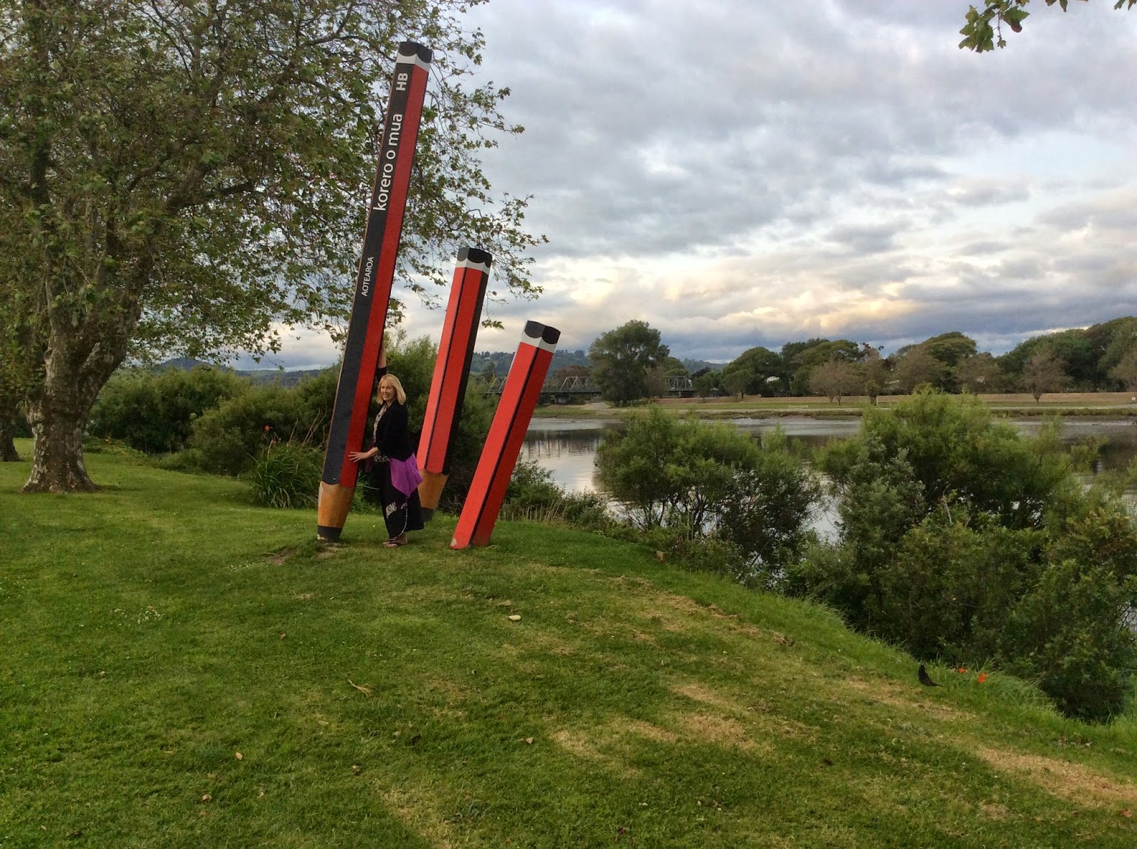
Perhaps my
favourite sculpture along the river walk.
I understand the contribution pencils have made to education – art,
literature and the sciences. We had
pencils in Shoshone, Idaho way back when I was a kid. Above… Sister Perron is going to write a love letter to Elder Perron.

Along the
river walk in Whanganui is this marker indicating a significant landing
place. The Inscription: “Te
Tauranga Waka O Nga Matua Tupuna – The landing place of the canoes of our
ancestors.” (Maori to English)

It was
raining (drizzle) so we decided to take a drive up the Whanganui River Road (50 miles – 80 kilometers – one way.) The road took over 30 years to construct, the
Whanganui River Road was opened in
1934. Construction was delayed many
times because of floods and slides.
Prior to the 1930s access to the remote settlements upstream was from a
boat that operated along the river. The
road is paved most of the way but very narrow and only wide enough for one car
in many spots. This is a view from the
top of Aramoana Summit looking up
river the direction we are headed. At
the end of the road is Pipiriki (still 40 miles away.) In Maori Aramoana means “the path to the
sea.”

Along the
road we found a farm house with a gas pump that had quite working years ago but
is still rusting away. Beautiful as the
mountains around it.

Ranana
(London) – the settlement features a beautiful Maori Marare as well as a
century old church shown in the next picture.

The early
Christian missionaries gave these Maori settlements along the river English
names. Ranana (London) is one of the
larger settlements. This is a century
old church in the settlement. The
settlement is not very large but people gather from up and down the river.

As mentioned
it was raining – seems even the sheep gather under the trees – if possible.

Here and in
all of the back country the bridges are old and are one way. The sign means the cars coming at me have the
right of way indicated by the big black arrow.
When you come to such a bridge watch the sign because it tells you who
has the right of way. They change.

Picturesque
mail box alongside the road. The fence
and mailbox add character to this life lived in this remote area.

No traffic
so Elder Perron just stopped in the road and walked back for a picture. Mainly to show you the long narrow road in this remote country side that went forever.

Hiruhaharama
(Jersusalem) We were told that Jerusalem would be a great photo opportunity if
the skies were clear. The settlement
would reflect in the water of the river and the hills around the place would
frame the picture. We came around the
corner and Jerusalem shrouded in clouds.
It was beautiful with the old church sticking up right in the middle of
the picture. Very fitting for the
Christmas season for a couple of missionaries to be here taking the picture.

The river
runs through it… a beautiful vista of the river below from taken from the road.

Towards the
end of the road we were bordering the Whanganui National Park.

From Pipiriki (end of the
road) Jet-boat trips are available up river (18 miles) to the BRIDGE TO NOWHERE. The bridge is a concrete road bridge spanning
the Mangapurua Stream Located deep in the forest of Whanganui National Park There are no roads leading to the bridge,
but it is a popular tourist attraction, accessible by mountain bike or tramping
on a variety of different trails, or by boat followed by a 45 minute (one way)
walk along maintained bush trails. It
was built across the deep Mangapurua Gorge to provide
access to an area where the government was opening up land in 1917 for
pioneering farmers, mainly soldiers who had returned from World War
I. The intention was to build roads to it later, but the area proved to
be so remote and unsuitable for farming that the venture failed and the farms
reverted to native bush.
We spent
eight hours exploring the remote Whanganui River country. A great day!

Goodbye to
Whanganui… We stopped on our way out of town for a picture of the city from a
viewing platform built on Dunn Hill. The
sculptured sphere shown several pictures back – along the river walk – is a
very small white dot across the river from Sister Perron in this picture. To Sister Perron’s right, up river and around
the bend, is the Wanganui River country we have just shown you in the previous
pictures.

Driving
North from Whanganui we passed through Patea.
Patea is the home of the outstanding Patea
Maori Club, whose 80s hit Poi-E is still one of the country’s favourite songs.
Patea has a rich Maori and European history. Driving though the town you pass
the Aotea Memorial Waka. Very
impressive! Waka in Maori is canoe or it
can be a word used to designate related tribes.
Here it does both.

In Opunake we
discovered a town where it’s history and it’s present-day is depicted in art
painted on most of the cities buildings.
Hence history on the side of this theatre building.

In this unique town of Opunake
we found a bronze statue of Peter Snell.
Peter Snell was born in Opunake in 1938.
Peter Snell is
one of the greatest athletes of all time and New Zealand’s Sport Champion of
the Twentieth Century. In the 1960’s he
won three Olympic Gold Medals for 800 and 1500 meters and two Commonwealth Gold
Medals for the mile and 800 yard track events.
He set seven individual world records during his athletic career,
including twice setting a new mark for the mile distance. He was also a member of New Zealand’s quartet
that broke the world 4x1 mile relay record.
Elder Perron was serving a mission in New Zealand in the 1960”s
obviously Peter Snell is one of his heroes.

It is obvious that this pole (telephone pole or power pole)
belonged to an era and locale long forgotten.
There were no other poles in the area – the pole is a sole survivor!
On our way back home we decided to traverse New Zealand’s
oldest Heritage Trail, the Forgotten World Highway a three-hour
scenic link between the West Coast and the Central Plateau. The old highway
follows ancient Maori trade routes and pioneering farm tracks, through
ambitious
historic settlements, untamed native bush and stunning natural scenery. We began in the town of Stratford and ended in Taumarunui on the Central Plateau. What the GPS said was to be a three hour drive took much longer as we stopped to take photographs.
historic settlements, untamed native bush and stunning natural scenery. We began in the town of Stratford and ended in Taumarunui on the Central Plateau. What the GPS said was to be a three hour drive took much longer as we stopped to take photographs.

The first of many markers along the Forgotten World Highway. Sister Perron has learned a lot from the
Polynesian YSA we work with… like never
have you photo taken unless you contort your face and flash a hand sign.

Along the Forgotten World Highway.

As we drove along the Forgotten World Highway we found something
unexpected. We were entering an independent republic! The small print on the sign reads “for a safe
and memorable passage please purchase a PASSPORT from the hotel or Border
Control (when manned.)” What?
Our investigation gave us
some background: “In the heart of the Stratford
District in Taranaki lies the small town of Whangamomona. When we say town, of course, what
we really mean is Republic.
When revised district boundaries tried to take Whangamomona out of Taranaki and put it instead
in the Manawatu-Whanganui region, the locals said bugger that. In
protest[November 1989], they declared themselves an independent republic, elected a series of
presidents, (only some of whom have been human), and got on with doing things
their way. Which is not too hard to do when you're a wee way off the beaten
track.”
First settled in 1895, the village of Whangamomona was
once a bustling frontier town, with up to 300 residents providing strong
service links to the hardy farmers trying to wrestle a living from the nearby
bush. The town experienced a great flood in 1924, then farm mergers and
rationalisation of the 1960s (cessation of railway service) the population has
declined to about 30 residents.

Sister Perron is headed for the headquarters of the Republic.
I do not know if it is for a potty break or to obtain a passport?

Sister Perron standing at the bar in the hotel – which
also serves as the passport office. You
can see the sign on the counter behind Sister Perron which very clearly
indicates this as the Passport Office.
The passport office clerk (waitress, bar tender, store
clerk and perhaps cook) was very friendly and funny. When we walked in and inquired about a passport her first question
was, “do you have your passport, I will be happy to stamp it for you!” They have an official stamp for the Republic of Whangamomona. We had left our passport back in our
apartment in Takapuna – how sad we were for having missed the opportunity. We asked about obtaining a passport from the
Republic of Whanamomona. It required a
$5 donation that went toward education.
Sister Perron is filling out her Passport.
Though the move (declaring themselves the "Republic
of Whangamomona") began as a pointed protest around New Zealand , the town
continued to hold a celebratory Republic Day once a year, during which a vote
for President was held. The day has become a local festival day, and attracts
visitors from throughout the North Island. In 2001, the celebration became
biennial, held in December (December 24th) to take advantage of the
summer weather.
The clerk invited us back to celebrate their independence
which last one day every two years.
Elder Perron indicated he would love to come back – asked if he could
run for office – and was told “you would be welcome to run for president but we
cannot guarantee that the vote would be on the up and up.” “Sounds just like every other Republic,” he
responded. We all laughed.

We are now
proud holders of a passport from the Republic of Whangamona. “It's
usually the presidential elections marred by scandal on Whangamomona Republic
Day that we are most noted for” the clerk pointed out: “Thousands of people will descend
on Whangamomona for possum-skinning, sheep-racing and political intrigue like
no other.” She promised. Then she
informed us of the important stuff, “this year they are going to take the unusual step
of calling on all visitors to help decide their fate as a
"micro-nation. We will be holding a
referendum to see if we should stay with the Whanganui-Manawatu region, try to
get back in with Taranaki or tell them both to stick it," she said.
"I think we know which way people will vote. We are also looking at the
possibility of joining the United Nations.”

We left the Republic with some mixed emotions… we had made a
new friend in that town! We had to stop
and take a picture!


After leaving the Forgotten World Highway at Taumarunui we
turned East and headed to the Lake Taupo area for the night. From a view point along the highway we had a
view of Mt. Tongariro and the Mt
Tongariro National Park shrouded in long hanging clouds in the disatance.

Our motel in Turangi at the South
end of Lake Taupo. It reminded Elder
Perron of a typical motel where fishermen would put up for the fishing trip. Just a room and a small café in the middle of
the outdoors.

Next morning we visited the Tongariro National Trout Centre.
Obviously a must stop!

The world famous Tongariro River reportedly the best trout fishing in New Zealand.

Elder Perron had to go down and stand on the banks of Tongariro
River – holding a stick – play-act a moment of fishing. Sister Perron was called upon to record this
great moment for posterity!

Turning
steam into power. Geothermal power
production is a small but significant part (16%) of New Zealands energy
generation capacity. Most of the
geothermal power plants are concentrated around the Taupo Volcanic Zone. Driving through that area we stopped long
enough to take a picture of one of the plant.
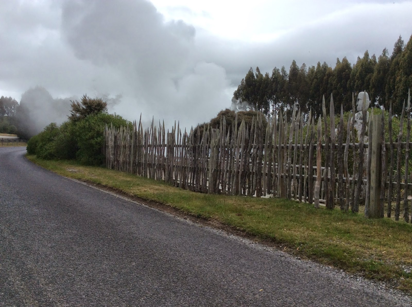
Maori Marae built around thermal pools. For generations, Māori have used thermal
waters for medicinal purposes, especially for skin complaints and rheumatic
diseases. They even used the hot pools for
cooking.
And that my friends is the end of this blog. We hope you enjoyed the little trip with us.
Until we write again....Aroha nui.
And that my friends is the end of this blog. We hope you enjoyed the little trip with us.
Until we write again....Aroha nui.